

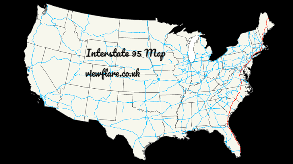
Interstate 95 runs roughly 1,900 miles along the East Coast, from Miami, Florida, to Houlton, Maine, at the Canadian border. It passes through 15 states and Washington, D.C. It is the longest north–south route in the Interstate Highway System, and it connects some of the most densely populated parts of the United States.Interstate 95 Map
A map of I-95 is only half the picture, though. The road behaves very differently in rural Georgia than it does in the Bronx. This guide covers the route state by state, how the exits work, where traffic tends to build up, and how to plan a drive that doesn’t wear you out.
Where Does Interstate 95 Start and End?
The southern end is in Miami, Florida, where I-95 meets US Route 1. The northern end is at the Maine–New Brunswick border near Houlton, where it connects to Canada’s Route 95.
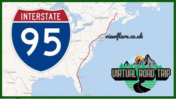
Along the way the highway links Miami, Jacksonville, Savannah, Richmond, Washington, D.C., Baltimore, Philadelphia, New York City, Providence, Boston, Portland, and Bangor (some of these by connecting routes, as noted below).
Most people picture a single straight line, but the road bends. It hugs the Atlantic coast through Florida, cuts inland through the Carolinas, bends around the Washington Beltway, and threads through the dense Northeast corridor. After Boston it runs through New Hampshire and Maine, where it feels like a different road entirely. Source:mapsofworld
Which States Does I-95 Pass Through?
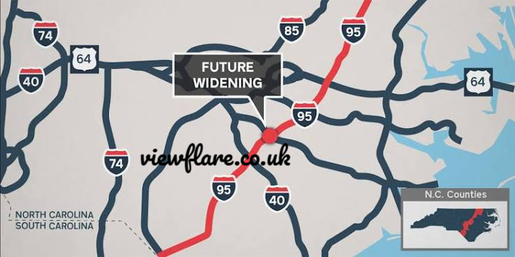
I-95 passes through Florida, Georgia, South Carolina, North Carolina, Virginia, Maryland, Delaware, Pennsylvania, New Jersey, New York, Connecticut, Rhode Island, Massachusetts, New Hampshire, and Maine, plus Washington, D.C.
Here is a south-to-north overview:
| State | What to Expect |
|---|---|
| Florida | Starts in Miami and runs through Fort Lauderdale, West Palm Beach, Daytona Beach, and Jacksonville. It’s the longest stretch in the south and includes express lanes near Miami. |
| Georgia | A short, mostly rural run past Brunswick and Savannah. |
| South Carolina | Passes inland of Charleston and crosses the state’s low country. |
| North Carolina | Passes Fayetteville and Rocky Mount on the way to the Virginia line. |
| Virginia | Richmond, Fredericksburg, and the congested Northern Virginia approach to D.C. |
| Washington, D.C. / Maryland | Shares the Capital Beltway area, then reaches Baltimore via the Fort McHenry Tunnel. |
| Delaware | A short stretch near Wilmington, with toll plazas. |
| Pennsylvania | Runs along the Delaware River past Philadelphia. |
| New Jersey | Works with the New Jersey Turnpike corridor toward the New York area. |
| New York | A brief but notoriously heavy stretch through the Bronx and Westchester. |
| Connecticut | Follows the Long Island Sound shoreline past Stamford, New Haven, and New London. |
| Rhode Island | Passes through Providence. |
| Massachusetts | Reaches Boston and continues north. |
| New Hampshire | The shortest stretch, a brief run through the Seacoast region. |
| Maine | The final, quiet stretch past Portland to Bangor and the Canadian border. |
Before publishing or planning a trip, confirm the details above with state transportation department maps, because routings near big cities (especially New Jersey, Boston, and Maine’s Portland area) involve connecting and parallel highways.
How Does the I-95 Route Divide Into Regions?
Drivers find it easier to think of I-95 in three segments rather than as one 1,900-mile line.
The Southern run (Florida to Virginia). Long, mostly flat stretches with lower traffic density outside the cities. This is where road-trippers make good time, and where long, boring stretches cause fatigue.
The Mid-Atlantic corridor (Washington, D.C. to New York). The busiest section. Four major metro areas sit within a few hours of each other, with heavy commuter and freight traffic in all of them. Tolls, tunnels, and bridges are common.
The New England stretch (Connecticut to Maine). Scenic in places, and it gets quieter the farther north you go. After the Boston area, traffic thins, and the Maine Turnpike section is a smooth, toll-based drive.
Major Cities Along Interstate 95
If you’re studying the route on a map, these are the anchor points:
- Miami and Jacksonville, Florida: the southern gateway and the state’s northern hub
- Savannah, Georgia: a classic stopover for drivers heading to or from Florida
- Richmond, Virginia: a convenient halfway rest stop between the Carolinas and D.C.
- Washington, D.C. and Baltimore: the start of the heavy-traffic corridor
- Philadelphia, Pennsylvania: reached along the Delaware River
- New York City area: the busiest crossing, with the George Washington Bridge and Cross Bronx Expressway
- Providence, Rhode Island and Boston, Massachusetts: the heart of southern New England
- Portland and Bangor, Maine: the gateway to the far north (Portland is reached via a connecting route, I-295, from the main line)
How Do Exit Numbers on I-95 Work?
Most states number I-95 exits by mile marker, so the exit number tells you how many miles you are from the state’s southern or western boundary.
If you’re at Exit 100 and need Exit 130, you have about 30 miles to go. This makes distance estimates simple, and it’s why exit numbers are so useful for navigation.
A few practical points:
- Mile markers restart in each state. Every state begins again at zero.
- Some states used older sequential numbering (Exit 1, 2, 3, and so on). Several have been converting to the mile-based system in recent years, including parts of New England, so signs in the same state can differ from older maps and printed guides. Check current signage and your state’s DOT.
- Mile markers help emergency services find you. If you need roadside help, the nearest marker and direction (northbound or southbound) are the most useful details to give.
I-95 Northbound and Southbound: Which Is Which?
Despite the road’s general north–south alignment, local signs sometimes use compass directions that seem wrong. In some metro areas, I-95 curves east–west for a stretch. Always go by the posted “North” or “South” on the route shield. A quick check before each junction avoids the most common mistake: being on the right highway in the wrong direction.
Where Does I-95 Traffic Get Worst?
Traffic on I-95 is predictable once you know the hot spots. The main trouble areas are:
- Miami to Fort Lauderdale: heavy commuter flow, with express lanes that carry variable tolls
- Northern Virginia: a prime commuter route toward D.C., with tolled express lanes
- Baltimore and the Fort McHenry Tunnel: a known chokepoint, particularly when there are incidents
- New York City: the Cross Bronx Expressway and George Washington Bridge approach, congested most of the day
- Connecticut: stop-and-go near Stamford, Bridgeport, and New Haven
- Boston: heavy congestion at rush hour and on summer weekends
My practical advice: Leave the big metro areas before 6 a.m. or after 9 a.m., avoid Friday afternoons and Sunday evenings on holiday weekends, and check live conditions before you start rather than just when you hit a jam.
How Do I Check I-95 Road Conditions and Live Traffic?
The most reliable sources are official ones:
- State 511 systems. Most states along the route (including Florida, Virginia, New York, and Maine) run a 511 service with road-condition data, camera feeds, and incident alerts.
- State DOT websites. They list planned lane closures and construction.
- Navigation apps. Google Maps and Waze offer real-time rerouting based on user reports.
Use more than one. An app might tell you the fastest route, but only an official source will tell you about a closed ramp or tunnel restriction.
Tolls on I-95: What to Plan For
I-95 itself is largely a free interstate, but several segments use toll facilities, and the Northeast has many of them:
- Express lanes in Florida and Virginia, which use dynamic pricing
- The Delaware Turnpike section
- Maryland toll facilities, including the Fort McHenry Tunnel
- The New Jersey Turnpike and bridge crossings into New York
- The Maine Turnpike through southern Maine
E-ZPass is accepted across most of the northern corridor, and Florida has its own SunPass system. If you’re renting a car, ask about toll-transponder fees before you leave the lot, as the charges can add up on a long trip.
Planning an I-95 Road Trip
A few lessons that apply whatever your route:
- Split the drive. Nonstop, the full route takes around 30 hours of driving time, but nobody should attempt it that way. Plan overnight stops in places like Savannah, Richmond, and Philadelphia.
- Plan tolls and fuel in advance. Fuel stops are frequent but busy near cities.
- Time your passage through the Northeast corridor. A one-hour error in your timing around New York or Boston can cost you two hours in traffic.
- Download offline maps. Coverage is generally good, but rural stretches in the Carolinas, Georgia, and Maine can have dead zones.
- Know your alternatives. US Route 1 runs roughly parallel to I-95 for much of its length and offers a slower, more scenic alternative when the interstate is jammed.
Where Can I Find an Interstate 95 Map?
Reliable options include:
- Official state DOT maps, which show exits and interchanges and are the most accurate for construction and numbering changes
- The Federal Highway Administration (FHWA), which publishes interstate system information
- Google Maps or Apple Maps for turn-by-turn and live traffic
- Printed road atlases (Rand McNally is a long-established example) for planning without a phone signal
For trip planning, I’d combine two of these: a printed or downloaded overview for the big picture, and an app for live conditions.
6. Custom FAQ Section
Where does Interstate 95 start and end?
I-95 starts in Miami, Florida, at US Route 1 and ends near Houlton, Maine, at the Canadian border, where it connects to New Brunswick’s Route 95.
Which states does I-95 pass through?
It passes through 15 states and Washington, D.C.: Florida, Georgia, South Carolina, North Carolina, Virginia, Maryland, Delaware, Pennsylvania, New Jersey, New York, Connecticut, Rhode Island, Massachusetts, New Hampshire, and Maine.
How long is Interstate 95?
It is roughly 1,900 miles long, which is about 30 hours of continuous driving without stops, traffic, or weather delays.
How do I find exits on Interstate 95?
Most exits are numbered by mile marker within each state, so the number tells you your distance from the state’s southern or western line. Use that to estimate how far away your exit is, and confirm with current signs, since some states have changed their numbering in recent years.
Where can I check I-95 road conditions and live traffic updates?
Use state 511 services and DOT websites for official closures and incidents, and navigation apps such as Google Maps or Waze for real-time rerouting. Checking both is the safest approach.